


|
MAP
Click the "Google Map Yes" to view the Google map page or Click any map to enlarge
|
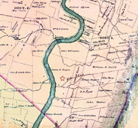
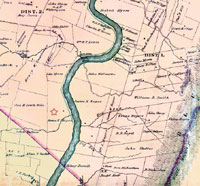
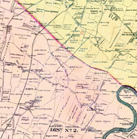
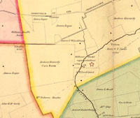
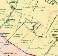
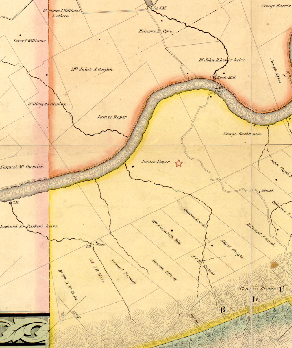
Roper Farms & Properties in Jefferson County, (West) Virginia A red star indicates the property described on each of the 1852 & 1883 Jefferson County map fragments.
|
|
|
View Larger Map
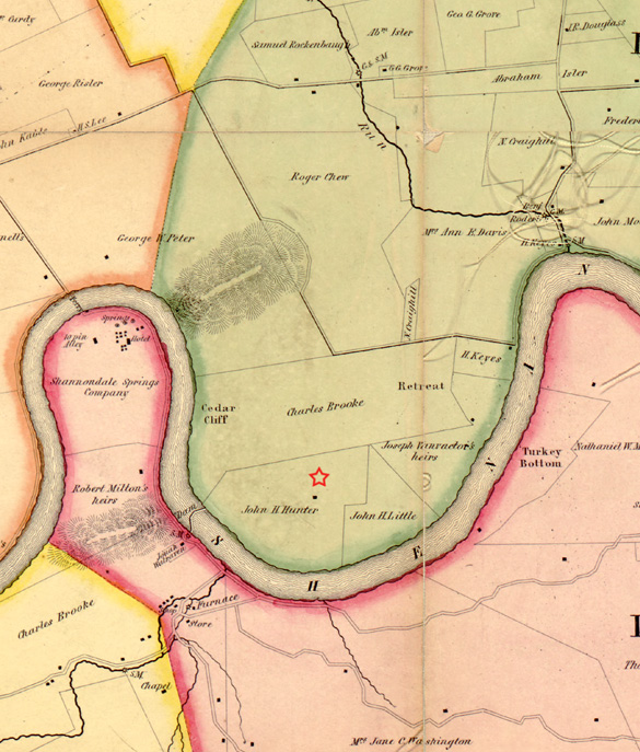
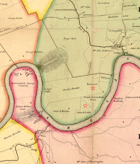
1852 Jefferson County map

1883 Jefferson County map
|
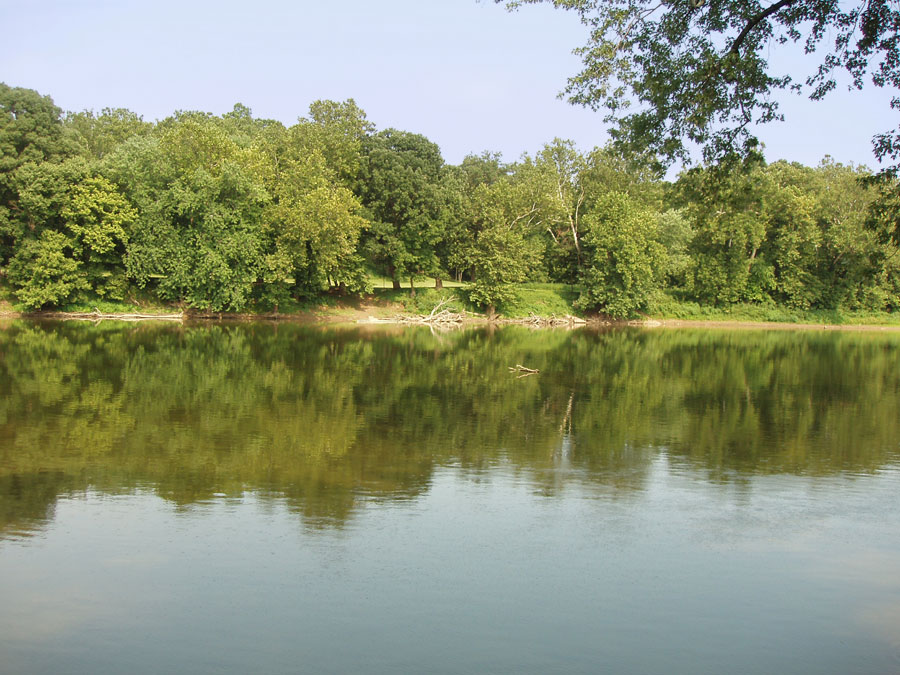
Mountain & Glade Tract - approx. 684 acres (712 & one quarter acres)October 9, 1797 an Indenture was made - Ferdinando Fairfax to Nicholas Roper - It included a tract of land called the "Mountain Tract" containing 684 acres and part of a tract called the "Glade Tract" acreage not yet determined. This tract of land was part of a larger tract owned by 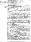 Ralph Wormely indeeded by Deed from the office of the late Proprietor of theNorthern Neck for 11, 716 acres (see land grant map) which was conveyed to James Wormley by his brother Ralph Wormley as trustee of said Ralph Wormley deceased by a deed dated 29th of January 1795 and by the said James Wormley sold to the said Ferdinando Fairfax by deed bearing date the 24th day of June 1797. - Frederick County, Virginia, Superior Court Deed Book No. 3 Part 2, 1796 - 1799 Page 343 - 345 (contains 3 pages) Taken from Nicholas Roper Time-line by Ms. Judy Meade Ralph Wormely indeeded by Deed from the office of the late Proprietor of theNorthern Neck for 11, 716 acres (see land grant map) which was conveyed to James Wormley by his brother Ralph Wormley as trustee of said Ralph Wormley deceased by a deed dated 29th of January 1795 and by the said James Wormley sold to the said Ferdinando Fairfax by deed bearing date the 24th day of June 1797. - Frederick County, Virginia, Superior Court Deed Book No. 3 Part 2, 1796 - 1799 Page 343 - 345 (contains 3 pages) Taken from Nicholas Roper Time-line by Ms. Judy Meade The will of Nicholas Roper devises this land to his heirs, naming Nicholas Osborn Roper his grandson and any future 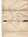 grand-children not yet born to be and equally divided. At James Roper's death he too devised this tact to his son's by will dated February 19, 1867, proved January 15, 1868(see below). On October 31, 1878 a plat was made and recorded of James Roper's Mountain land division. grand-children not yet born to be and equally divided. At James Roper's death he too devised this tact to his son's by will dated February 19, 1867, proved January 15, 1868(see below). On October 31, 1878 a plat was made and recorded of James Roper's Mountain land division.  The Mountain Tact would be divided again by the heirs of James Michael Roper. The portion called the "Glade Tract" was devised to James Nicholas Roper son of William Thornton Roper by Will of James Roper (see below). This Mountain tract remained in the family until the yearly 1900's when it had to sold due Chancery, heirs wishing to have the money instead of the land. (photo was taken from the west bank of the Shenandoah river looking across to the Glade and Mountain tract c. 2005) The Mountain Tact would be divided again by the heirs of James Michael Roper. The portion called the "Glade Tract" was devised to James Nicholas Roper son of William Thornton Roper by Will of James Roper (see below). This Mountain tract remained in the family until the yearly 1900's when it had to sold due Chancery, heirs wishing to have the money instead of the land. (photo was taken from the west bank of the Shenandoah river looking across to the Glade and Mountain tract c. 2005) Item.- I devise to my said Grand Son James Nicholas Roper, five hundred acres of my larger tract of land situated as before mentioned, on the South East side of the Shenandoah river; bounded by the river on the Northwest, by Perkin's heirs on the Southwest, George Backhouse on the North East - and on the South east by the parcels of land herein before devised to my sons James Michael and Washington Albert - for and during the natural life of him the said James Nicholas Roper and no longer; ; and at his death, I devise the same, in equal portions, to any son or sons of his, born in lawful wedlock, that may be then living, or of which his wife may then be ensient.- Said son or sons to take as purchasers, and not by way of entail.- and in default of there being no such son or sons living as aforesaid, then to my two son Washington Albert in fee simple - The tract of land on the Southeast side of the Shenandoah river; out of which I have herein before devised one hundred and ten acres to my son James Michael; and a like quantity to my son Washington Albert; and the residue of five hundred acres to my Grand son James Nicholas Roper, is to be divided as follows to wit - Beginning at the Southeast corner of the general tract, in the line of Henson Elliot, the course is to be down the line, with Parker's heirs toward the river, a sufficient distance, so as by running thence across the whole tract to Backhouse's line, the quantity of two hundred and twenty acres may be thrown off next to the mountain and adjoining the lands of Henson, Elliot, Brooke, and others - the North eastern half in devised as hereinbefore mentioned to my son James Michael, and the South western half to my son Washington Albert - I have already had a survey of this line made by S Howell Brown, which will more fully explain my intentions in this respect-
|
|
|
Google Map Yes
View Larger Map
1852 Jefferson County map

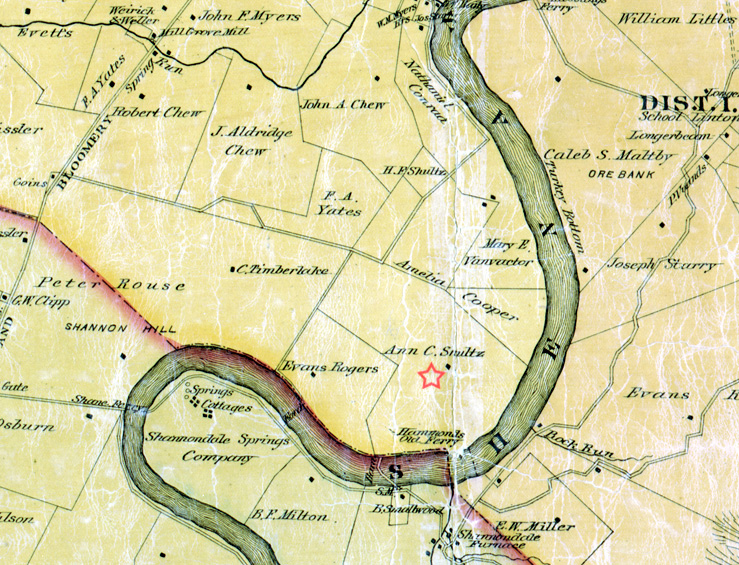
1883 Jefferson County map
|
River Farm on the West bank of the Shenandoah River - approx. 400 acresThis tract of land would be joined with the above Mountain & Glade tract making a total of 1112 acres 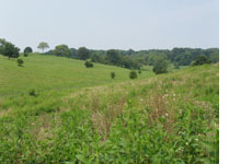
15 June 1807 - Jefferson County, Virginia-Bargain & Sale: Nicholas purchases from Ferdinadno Fairfax and wife, for "twenty two thousand two hundred and forty five dollars", two tracts of land: the Mountain Tract containing 712 1/4 acres "lying upon the Eastern side of the Shenandoah River", and the River Farm on the west bank containing 400 acres, "which two tracts of land are parts of the lands of James Wormeley, which he sold to said Fairfax in the year 1797 [Frederick Co., VA Superior Court Book No. 4, pg 72], the original tract out of which the whole of said lands were taken having been granted to Mann Page of Gloucestor, by Lord Fairfax and also by an including patent for surplus lands to Ralph Wormeley Father of the said James Wormeley." "The said two tracts having been given in security by mortgage to the said Roper". . . "containing together eleven hundred and twelve acres and a quarter of an acre". Eliza B. Fairfax relinquishes her dower rights; the dower release language states that the 2 tracts were "sold and conveyed unto Nicholas Roper [by] fee simple".- Jefferson County, WV Deed Book #4, 1807-1808, pp 139-141. See above transaction dated 9 October 1797. 22 June 1807 - Jefferson County, Virginia--Release of Mortgage: "the said Roper, for his consideration of the sum of Four thousand three hundred & fifty pounds with its interest (The receipt whereof he doth hereby acknowledge). . . doth release [,] relinquish, and quit claim to, unto the said Ferdinando Fairfax . . .all those two Tracts of land called River farm and the Mountain Tract which by a Deed of Mortgage dated the [9th] day of [October] in the year 1797 the said Fairfax conveyed to the said Roper for the purpose of securing the payment of the said sum of money & Interest excepting so much of the said Tracts as are contained in said Fairfax's Deed of Bargain & Sale to said Roper in fee simple, bearing date the 15th day of the present month: To have and to hold the said mortgaged premises as excepted before excepted unto him the said Fairfax, his heirs and assignes forever, free from all claims of the said Roper and all persons claiming under him, with the exceptions of the part conveyed & Sold to him in fee simple as aforesaid."--Jefferson, WV Deed Book 2, 1802-1805, pg 142. See above transactions dated 15 June 1807 and 9 October 1797. (Taken from Nicholas Roper Time-line by Ms. Judy Meade) This land was devised by Will of James Roper to his eldest son Nicholas Osbourn Roper (see below) Item.- I devise to my son Nicholas Osborne, all of my tract of land on the west side of the Shenandoah river, adjoining the lands of Henry Castleman, James Lewis, and others, upon which Daniel Snyder now resides; and containing four hundred acres, be the same more or less, for and during his natural life and no longer; ; and at his death, I devise the same, in equal portions, to any son or sons of his, born in lawful wedlock, that may be then living, or of which his wife may then be ensient.- Said son or sons to take as purchasers, and not by way of entail.- and in default of there being no such son or sons living as aforesaid, then, in equal portions to my grand son James Nicholas Roper, son of my deceased son William Thornton Roper, for and during the natural life of him the said James Nicholas, and no longer; and at his death to any son or sons of his, born in lawful wedlock, that may be then living, or of which his wife may then be ensient.- Said son or sons to take as purchasers, and not by way of entail.- and in default of there being no such son or sons living as aforesaid, then to my son Washington Albert in fee simple -
|
|
|
|
|
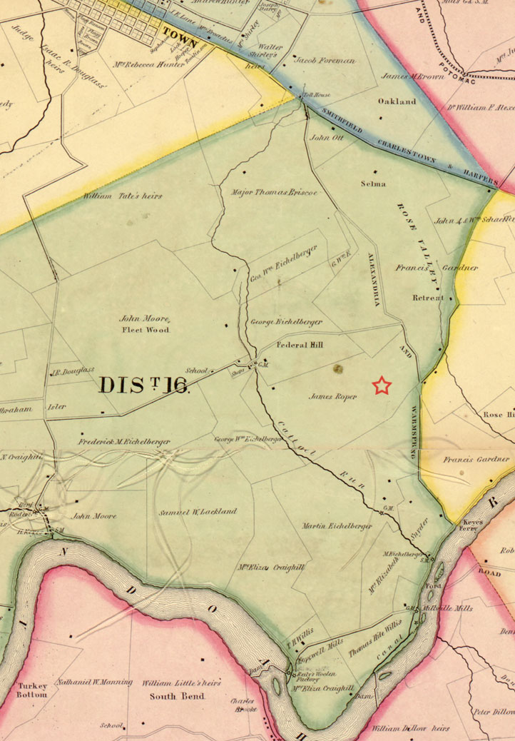
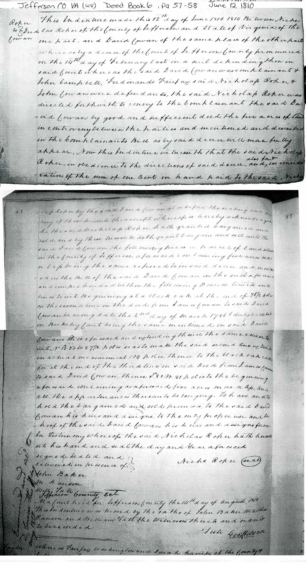
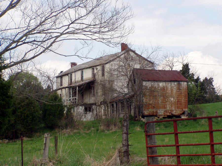
 Cat-Tail Run - 270 acres Cat-Tail Run - 270 acres On April 6, 1805, Nicholas Roper bought 126 acres from Ferdinando Fairfax, his wife and William Page; Jefferson County Deed Book 2, 1802-1805, page 447; cost $3, 150. On June 12, 1810, Nicholas sold 5 acres of this land for one cent to David Cowan per decree of the Court of Jefferson County; Deed Book 6, Page 57-58. This tract of land (Cat-Tail Run) was leased by Nicholas Roper to James Roper for 999 years on the condition that James pay Nicholas and Mary his wife $100 annually during their lifetimes and after their deaths pay $2 annually to Gersham Richards. Judy Meade could not locate the record for this transaction.. James Roper bequeathed this tract of land to his wife Elizabeth Laley Roper per Will dated November 11, 1865 Item.- I desire to my wife
Elizabeth Roper my farm on Cat-tail run – in Jefferson county, adjoining the lands of Eichelberger, Gardiner and others; and containing about Two hundred and seventy Seven acres; including the original tract; and about forty acres, subsequently purchased; for and during her natural life, and no longer. The remainders in said tract of land, I devise to my son William Henry Harrison, for and during his natural life and no longer; and at his death, I devise the same in equal portions, to any son or sons of his, born in lawful wedlock, that may be then living, or of which his wife may be ensuit = Said sons to take as purchasers, and not by way of entail. And in default of their being no such son
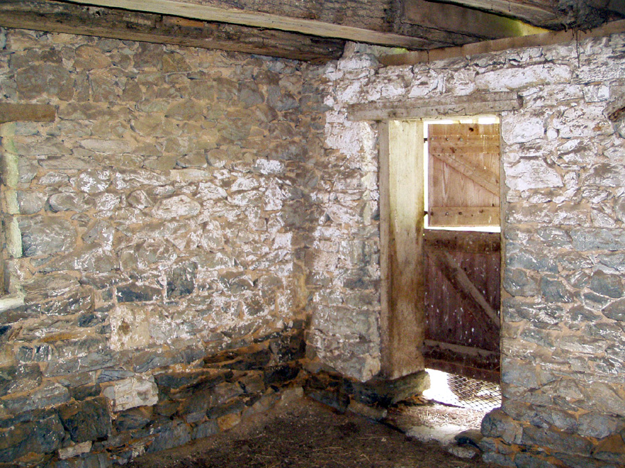
or sons living as aforesaid; then, in equal portions, to my sons James Michael and Washington Albert, and to the Survivor of them, for and during their natural lives or life, and no longer; and in the event that neither of my said two sons should be alive at the death of my said son William Henry Harrison, he having died with out leaving male children as aforesaid, then to my heirs at law in fee simple. This land remained in the family until the late circa 1930's The farm is now owned by a large limestone quarry operation; it will be mined for gravel in the near future. This photo was taken summer of 2005. The home has been abandoned for many years; it's not yet determined if this was the original dwelling. Another point of interest: When Nicholas first acquired the property it bounded on the Old Warm Spring Turnpike. This road would have been a main thoroughfare to "Bath" now known as "Berkeley Springs" in Morgan County, WV. The farm is now owned by a large limestone quarry operation; it will be mined for gravel in the near future. This photo was taken summer of 2005. The home has been abandoned for many years; it's not yet determined if this was the original dwelling. Another point of interest: When Nicholas first acquired the property it bounded on the Old Warm Spring Turnpike. This road would have been a main thoroughfare to "Bath" now known as "Berkeley Springs" in Morgan County, WV.
|
|
|
View Larger Map
1852 Jefferson County map
1883 Jefferson County map
|
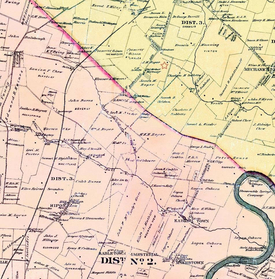
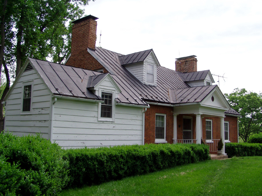
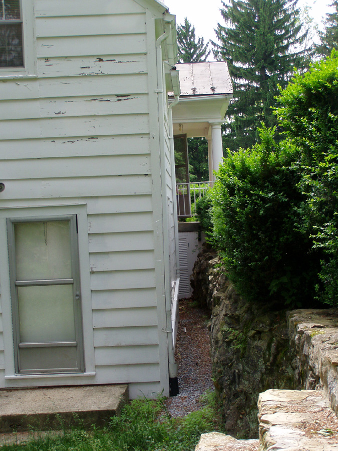
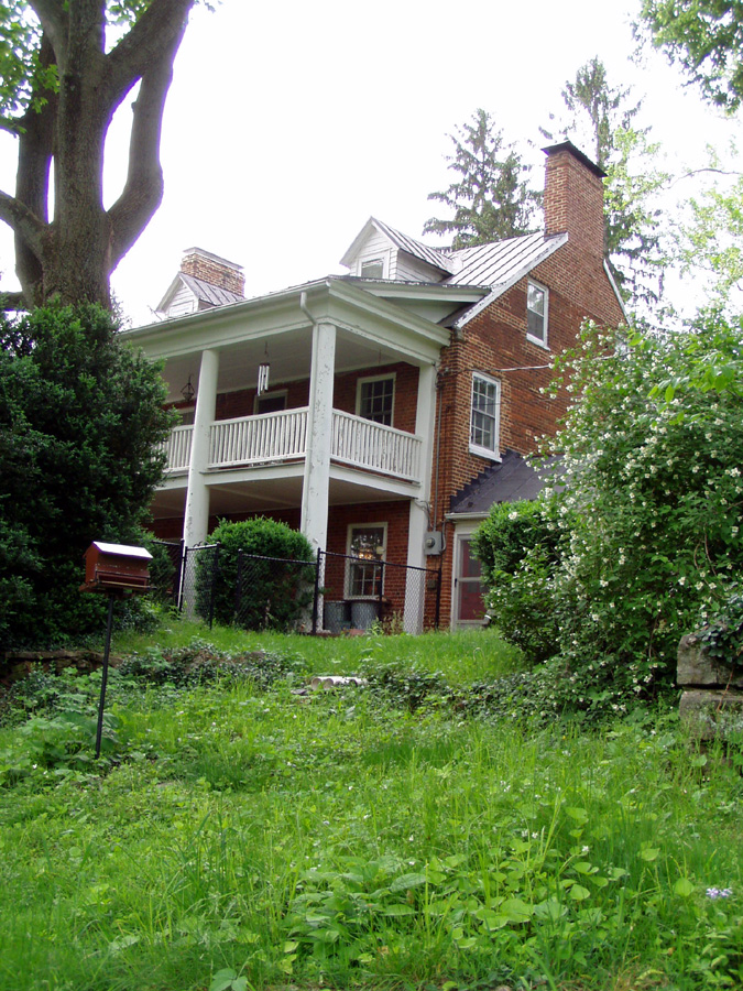
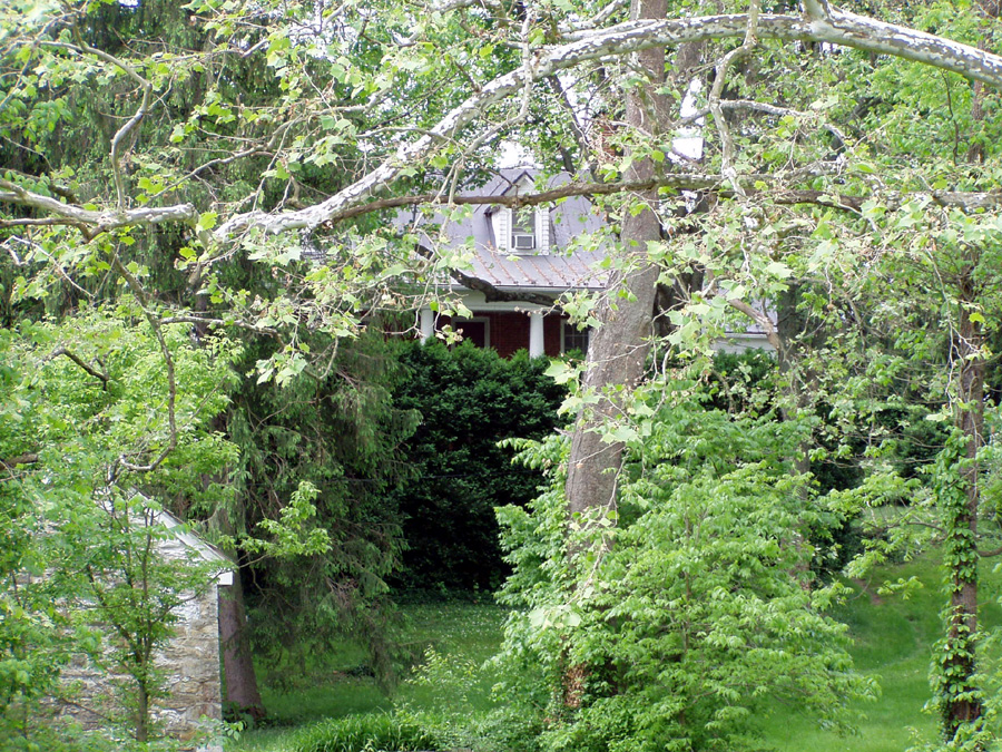
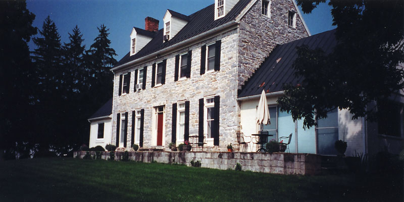
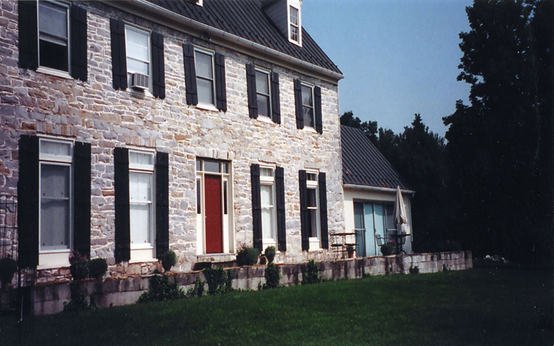
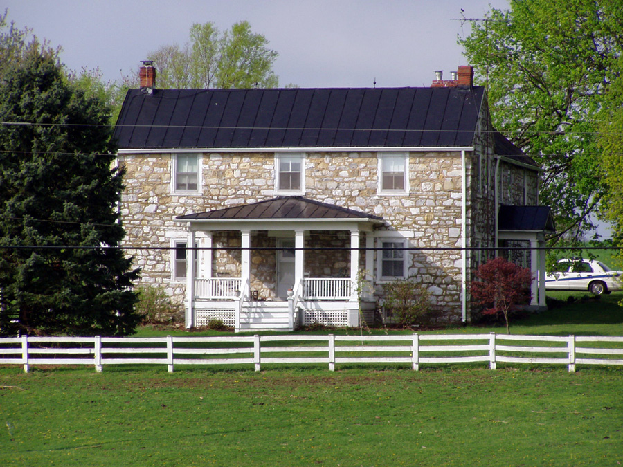
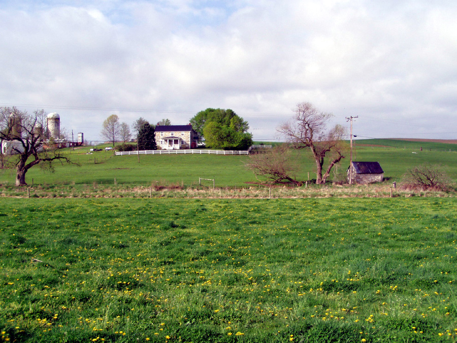
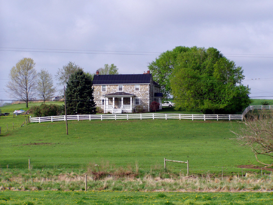
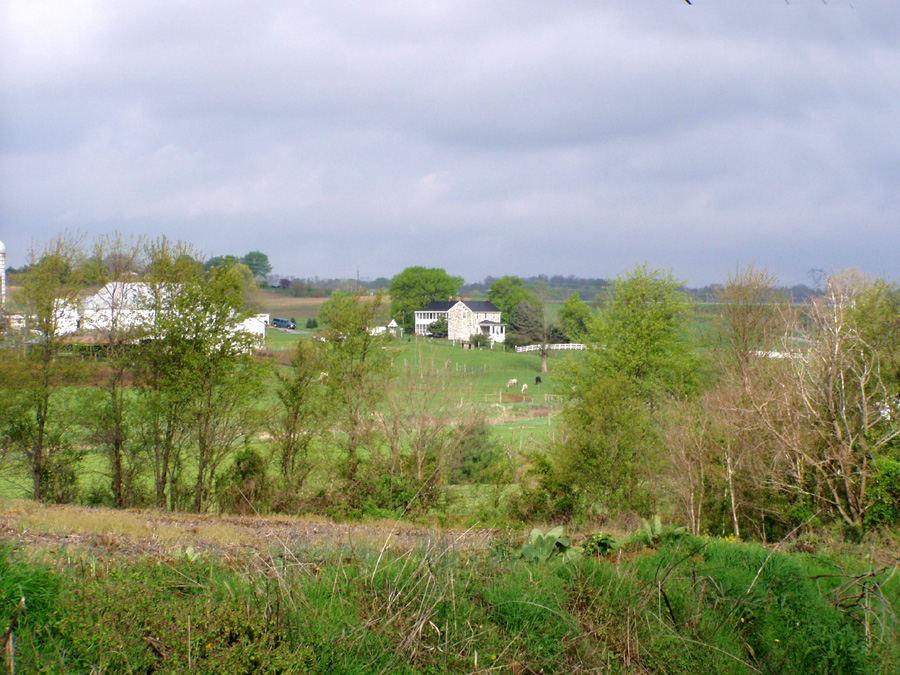
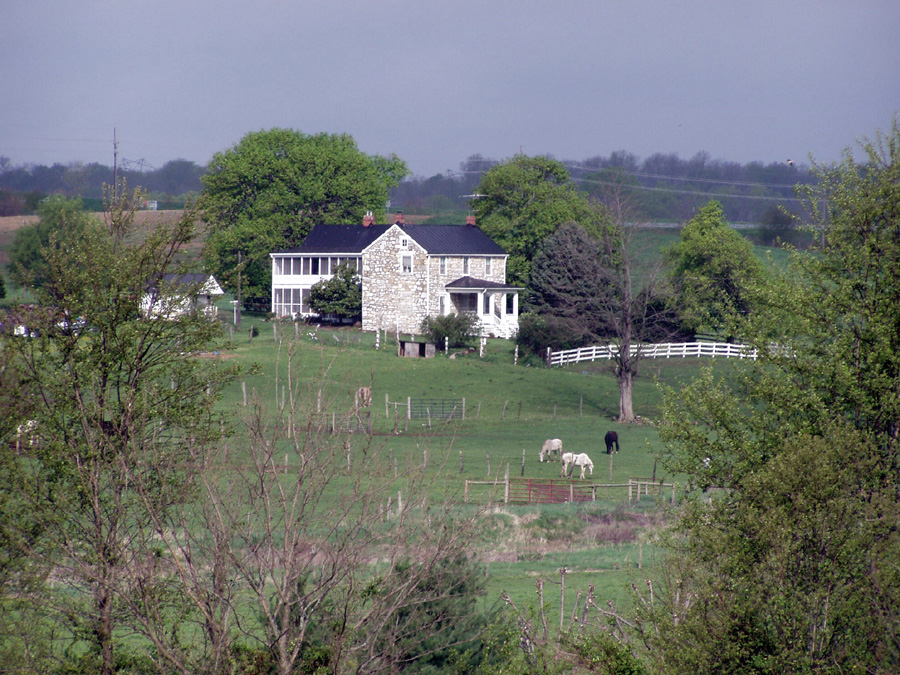
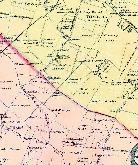
Home Farm or Hillside Farm - 310 acresThis tract of land was put together from several parcels of land to make a 310 acre farm James Roper referred to as his "Home Farm". Please note; It's also been referred to as "Hillside Farm" due to the main house is positioned on a hillside requiring a bridge to enter the front door (see photos below). The last generation of Roper's who own the property referred to it as the "Brick House Farm". Today it is called "Little Elmington" named after a Clarke County farm called "Elmington". My report on this property is incomplete; further research is need to obtain all deeds and transactions for this property. Viewing the google map to the left; The green arrow is positioned at the home, the remainder of the farm has been divided and developed. The original Roper lines can still been seen and compared with the 1883 and 1852 Jefferson County maps. In James Roper's Will dated November 11, 1865. Jefferson County, WV, Recorders Will book, page 70 - 78, this tract was devised to his son James Michael Roper, first son of his second wife Elizabeth Laley. Item.- I devise to my son James Michael, my home farm, consisting of several parcels of land, purchased from Samuel Howell; Elizabeth Dorsey, John B. Packett, William Hooff and James L. Ranson: Containing in all about three hundred and ten acres, to be taken from my larger tract of land situated on the South east side of the Shenandoah river, adjoining the lands of the late Judge Penkin's heirs and others: and to be laid off in the North East corner of the same, in the manner hereinafter Specifically directed: for and during his natural life and no longer: and at his death I devise the same in equal portions to any son or sons of his, born in lawful wedlock that may be then living, or of which his wife may then be ensient: Said son or sons to take as purchasers, and not by way of entail - And in default of there being no such son or sons living as aforesaid; then in equal portions to my two sons William Henry Harrison and Washington Albert and the survivor of them, for and during the natural lives of life of my said two last mentioned sons and in the event that neither of my said two sons should be living at the death of my said son James Michael, he having……} James Roper {seal} {second sheet of James Roper's Will} died without leaving male children as aforesaid, then to my heirs at law in fee simple.
|
|
|
Mount Hammond - 200 acres approx. This tract of land was devised by James Roper to his Eldest daughter Ann Catherine Schultz by will dated November 11, 1865, Jefferson County, WV, Recorders will book, page 70 - 78. It reads as follows.
Item.- I desire to my daughter Ann Catherine, now the wife of Henry F. Scholz, the tract of land in Jefferson County; part of which I purchased from John H. Little and wife, and the larger part from Charles Brooke and wife; which is described as follows, to wit: Beginning at the Southwest corner of the tract purchased from Little and wife, and a corner to the tract purchased from Brooke and wife, running thence S 47°, 57 1/2' E, 81.7 poles to a Stone; thence to same course continued 70.6 poles to the Shenandoah river; the whole distance of said course being about 152 poles – Thence with the meanders of the river to a stake near a large Elm stump, a corner to the Cedar Cliff Tract; Thence with the lines of the same N 2° 30` W. 49.3 poles to a stake and stone – thence N. 20° 27` E. to the North corner of the Cedar Cliff farm – thence N. 59 1/2° W. 132.1 poles to Rouss line, thence with the same N-30 ½ E to a corner of Rouss and Chews heirs; thence in a straight line to the beginning; Supposed to contain about Two hundred acres, be the same more or less. – The said devised is made to my said daughter for and
during her Natural life and no longer; and for her sole and separate use and benefit, in like manner as if she were unmarried; and the said life estate is in no manner to be subject to the marital rights, or to the debts or liabilities of her present; or any future husband. The remainder in said tract of land I devise to my son Washington Albert, for and during his natural life and no longer; and at his death I devise the same in equal portions, to any son or sons of his, born in lawfull wedlock, that may be then living; or of which his wife may then be ensuint. And in default of any such son or sons living as aforesaid, then in equal portions, to my sons James Michael, and William Henry
Harrison and the survivors of them, for and during the natural lives of life of my said two last mentioned sons shall be living at the death of my said son Washington Albert, he having died without leaving male children as aforesaid, then to my heirs at law in fee simple.
Photos provided by Ms. Judy Meade
|
|
|
|
|
Retreat - 259 AcresThis tract of land was devised to Amelia Virginia Cooper by last will and testament of her father James Roper dated November 11, 1865. Jefferson County, WV, Recorders Will book, page 70 - 78. The acreage was not stated in the will only a description was given as follows. Item,- I devise to my daughter Amelia Virginia all the north end of the tract of land, referred to above, as having been purchased from Charles Brooke and wife known as the “Retreat”; together with the larger portion of the tract purchased from Little and wife; The tract of land hereby devised, may be better described by beginning at the month of the lane, corner to Rouss and Chew’s heirs, running thence by a Straight line across the Brooke tract, to the corner of the John H. Little land, that is the corner of it, and the original Hammond tract, near also to Vanvactor’s corner – Thence with the line between the Hammond and Little tracts, Southward, passing the first angle, Straight on to the Shenandoah river – so as to throw much the larger portion of the Little tract into the tract
here intended to be divided – This devise is made to my said daughter, for and during her natural life and no longer; and to her sole and separate use if She should hereafter marry; So as is no manner to be subject to the Marital rights, or the debts or liabilities of any future husband she may have, The remainder in said tract of land, I devise to my son James Michael, for and during his natural life, and no longer; and at his death I devise the same, in equal portions to any son or sons of his born in wedlock, that may be then living; or
of which his wife may then be ensuint – said sons to take as purchasers and not by way of entail. And in default of them being any such son or sons living as aforesaid; then in equal portions to my sons William Henry Harrison and Washington Albert, and the survivor of them, for and during the natural lives of life of my said to last mentioned sons. And in the event that neither of my said two sons should be alive at the death of my said son James Michael he having died without male children as aforesaid; then to my heirs at law in fee simple. A deed of trust for a sum of $1,000 was made on 30th day of April 1910 by the heirs of James Michael Roper of the first part and Forrest W. Brown trustee of the second a part containing 181 acres. Jefferson County, WV, Deed Book 104, page 335 & 336.
|
|
|
|
|
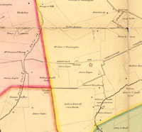
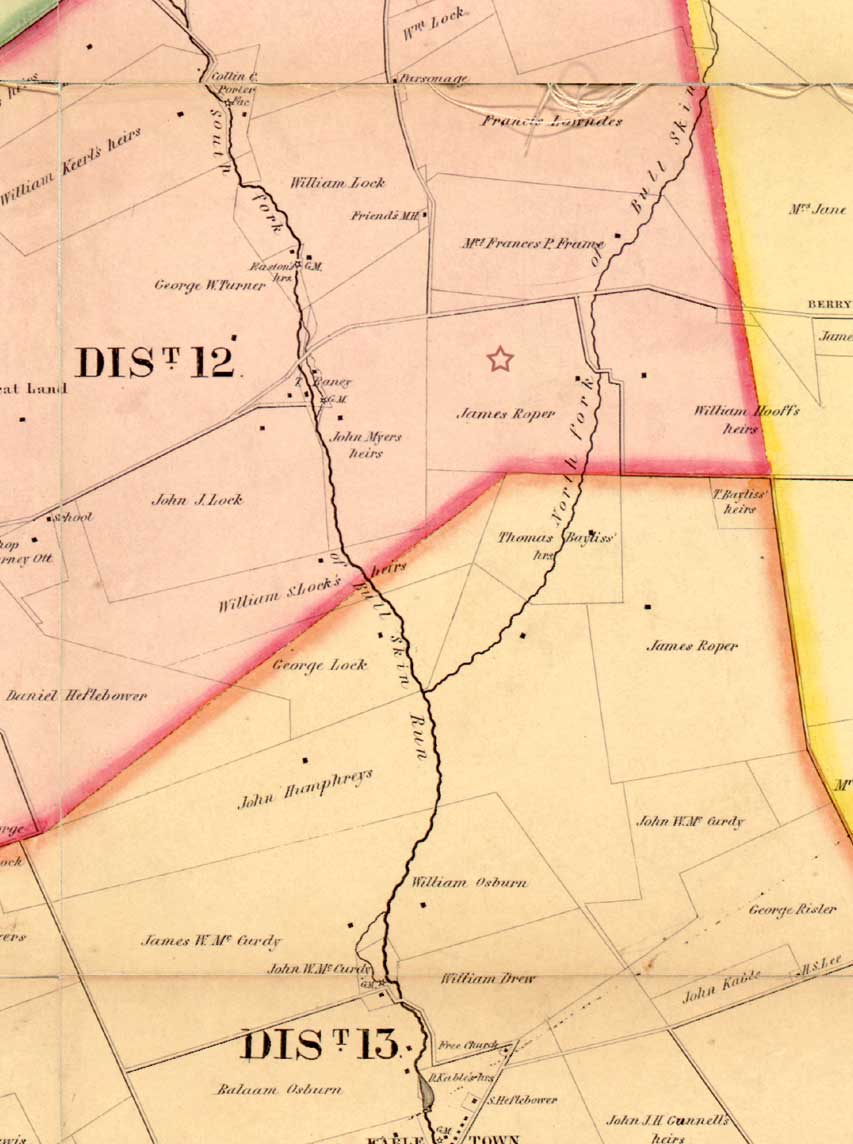
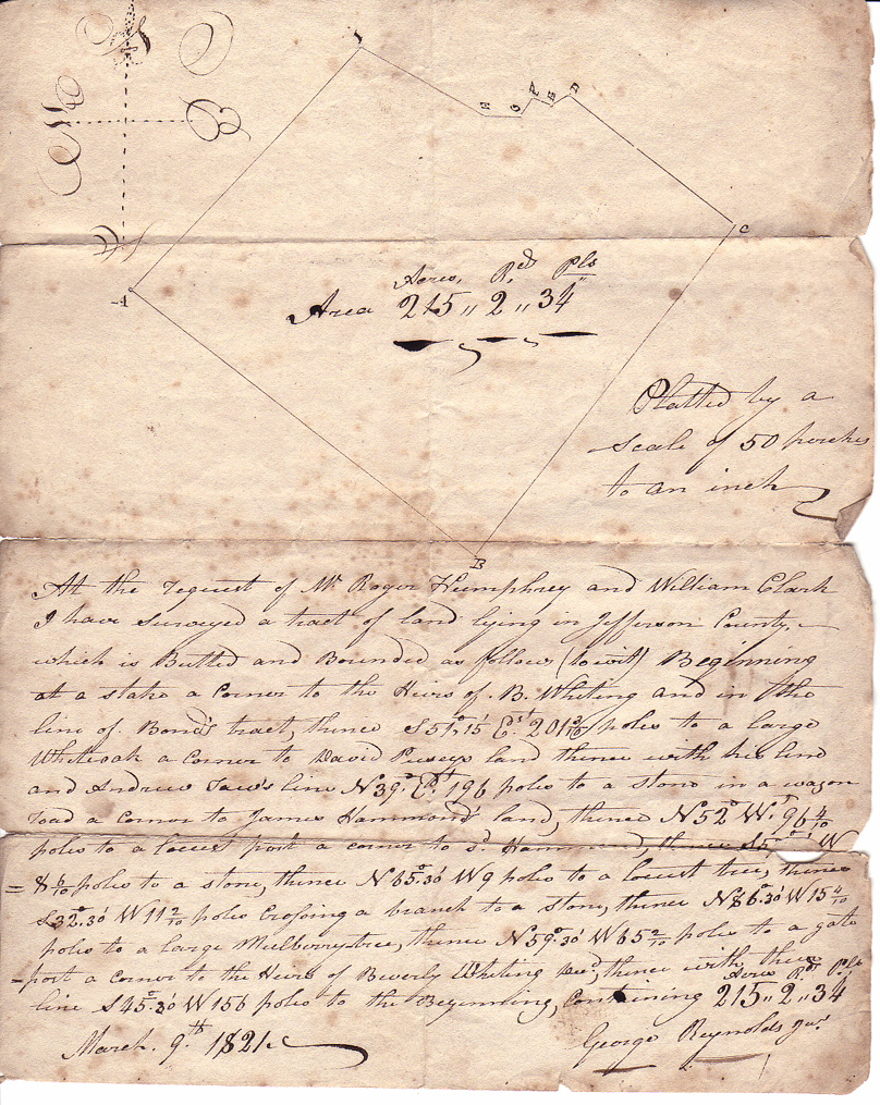
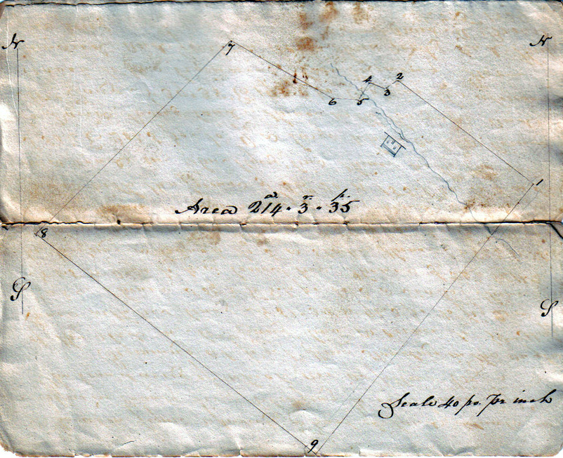
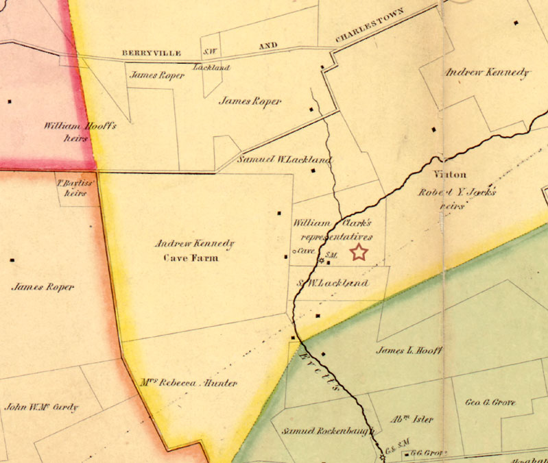
 Rock House Farm on the Bull Skin - 215 acres Rock House Farm on the Bull Skin - 215 acres James Roper bought this 215 acres tract of land called the "Rock House Farm" in 1823 from the heirs of Roger Humphrey. (See original plat) It was devised to Washington Albert Roper by last will and testament of his father James Roper dated November 11, 1865, Jefferson County, WV, Recorders Will book, page 70 - 78. (note: other tracts of land were devised to W. A. Roper in James Ropers Will) Item,- I desire to my son Washington Albert, all of my stone - house tract of land, lying on the North fork of Bullskin, and containing two hundred and fifteen acres, be the same more or less, and including also a lot of land adjoining, which I purchased from Whiting's heirs, and which lies between the original Stone house tract, and the Berryville Turnpike, on the north corner; also one hundred and ten acres of my larger tract of land situated on the south east side of the Shenandoah river: to be laid off in the South East corner of said tract adjoining the lands of Backhouse, Smith and others, in the manner hereinafter specially, directed: also the lot of land purchased by by [sic] me from, William Clarke's heirs lying on the north side of Evitt's run, adjoining the lands of Lack's heirs, Lacklands heirs &, and containing the twenty one acres, be the same more or less, adjoining the home farm, and the lands of Lacklands heirs; which lot is divided from the home farm by a chestnut rail fence; which however is to belong to the home farm; - for and during his natural life and no longer; and at his death, I devise the same, in equal portions, to any son or sons of his, born in lawful wedlock, that may be then living, or of which his wife may then be ensient.- Said son or sons to take as purchasers, and not by way of entail.- and in default of there being no such son or sons living as aforesaid, then, in equal portions to my two sons James Michael and Washington Albert and the survivor of them for and during the natural lives of life of my said two sons should be living at the death of my said son Washington Albert, he having died without male children living as aforesaid, then to my heirs at law in fee simple -(See Will of James Roper)  The original plat for this tract of land was drawn in 1821 for Roger Humphrey (see plat above). In 1823 the property was conveyed by heirs of Roger Humphrey to James Roper by a series of bonds dated 1826 - 1828. On May 31, 1828 James Roper received a release for the property. A new plat was drawn on April 13, 1829 Humphrey to Roper (see plat to right) being the final transaction. To see all transaction go to Deed page it will be referred to as the Rock House farm or farm on the Bull Skin. (Note: The original property line as seen through the early 19th century plats and both S.H. Brown maps 1852 & 1883 can still be seen today from satellite shown on google map. The original plat for this tract of land was drawn in 1821 for Roger Humphrey (see plat above). In 1823 the property was conveyed by heirs of Roger Humphrey to James Roper by a series of bonds dated 1826 - 1828. On May 31, 1828 James Roper received a release for the property. A new plat was drawn on April 13, 1829 Humphrey to Roper (see plat to right) being the final transaction. To see all transaction go to Deed page it will be referred to as the Rock House farm or farm on the Bull Skin. (Note: The original property line as seen through the early 19th century plats and both S.H. Brown maps 1852 & 1883 can still be seen today from satellite shown on google map.
click images to enlarge
|
|
|
|
|
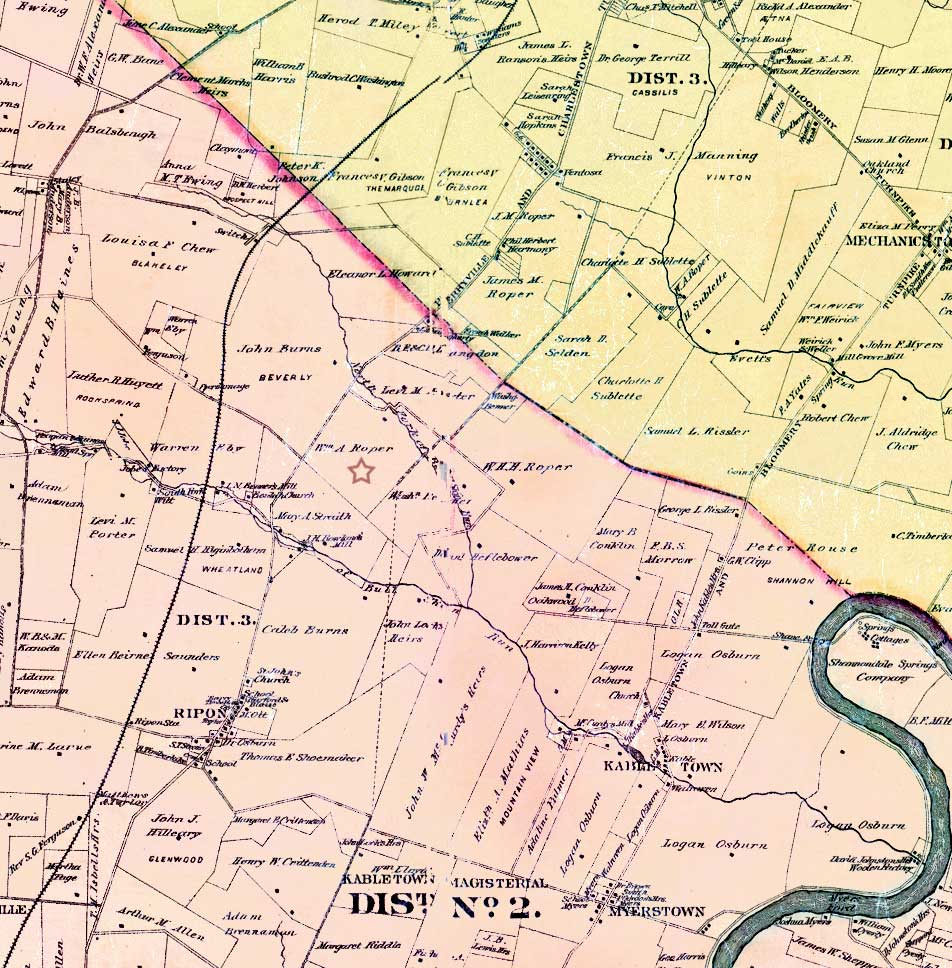
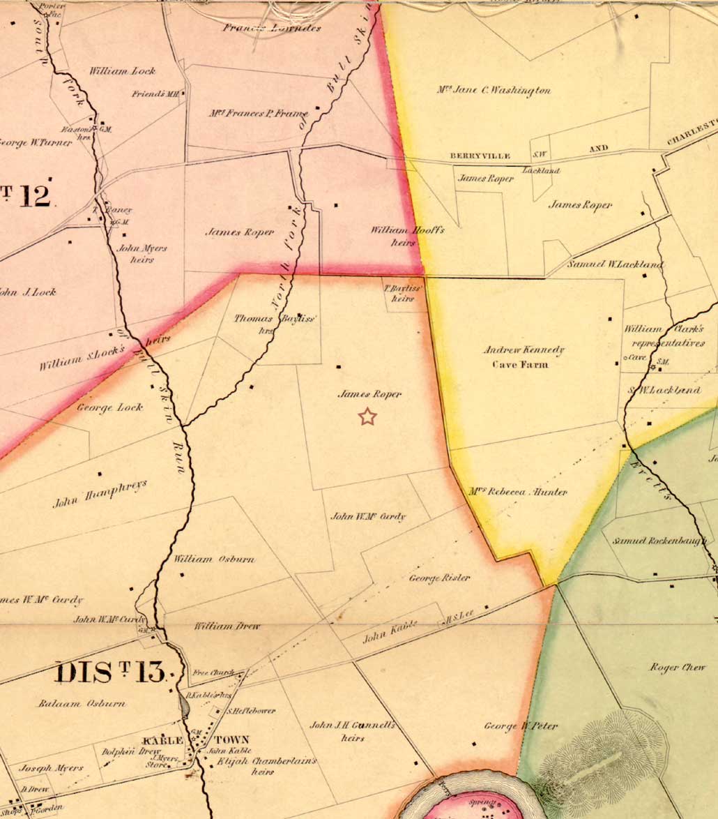
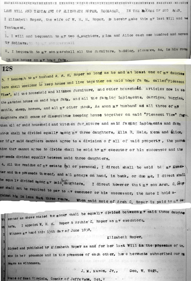
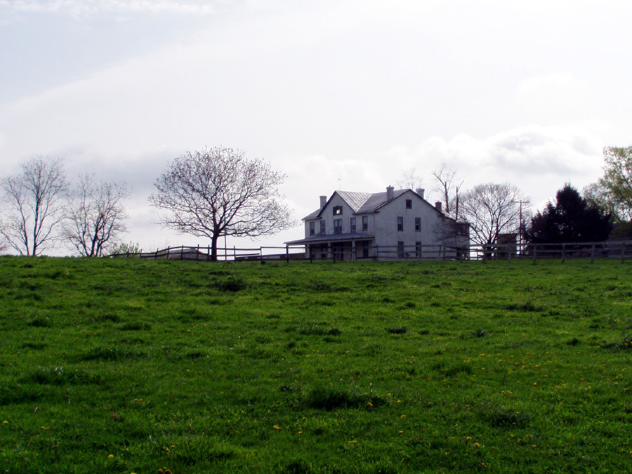
Pleasant View- 333 acres This tract of land contained approximately 333 acres. James Roper bought this farm from Mrs. Law's executor and Thomas Lee, it would become known as "Pleasant View". My report on this property is incomplete; more research  is needed to obtain copies of deeds and transactions. is needed to obtain copies of deeds and transactions. This tract of land known as "Pleasant View" was devised to William Henry Harrison Roper son of James Roper by last will and testament dated November 11, 1865, Jefferson County, WV, Recorders Will book, page 70 - 78. Another point needs to be addressed; In the will of Elizabeth Lalley Roper wife of William Henry Harrison Roper she devised the said farm "Pleasant View" to her husband and daughters as long as they keep house together. The question is when did Elizabeth acquire the said farm. (see will abstract on right) Item.- I devise to my son William Henry Harrison, all the lands I purchased of Mrs. Law's Executor and Thomas Lee, adjoining the lands of McCurdy, Humphrey's & others, And containing in all about three hundred and thirty three acres; be the same more or less, for and during his natural life, and no longer; and at his death, I devise the same, in equal portions, to any son or sons of his, born in lawful wedlock, that may be then living, or of which his wife may then be ensient.- Said son or sons to take as purchasers, and not by way of entail.- and in default of there being no such son or sons living as aforesaid, then, in equal portions to my two sons James Michael and Washington Albert and the survivor of them for and during the natural lives of life of my said two sons should be living at the death of my said son William Henry Harrison, he having died without male children living as aforesaid, then to my heirs at law in fee simple -
|
|
|
1852 Jefferson County map
1883 Jefferson County map
|
Roper's Mill on fork of Evitt's Run - 21 acres
|
|
|
|
|
|


